


Le Brignon

7217Lionel
User
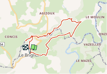

Length
9.3 km

Max alt
949 m

Uphill gradient
265 m
Km-Effort
12.9 km

Min alt
742 m

Downhill gradient
266 m
Boucle
Yes
Creation date :
2025-06-23 07:04:01.028
Updated on :
2025-06-23 09:45:13.785
2h40
Difficulty : Difficult

FREE GPS app for hiking
 SityTrail
IGN / Geographical institutes
SityTrail Plus
The world is yours!
About
Trail Walking of 9.3 km to be discovered at Auvergne-Rhône-Alpes, Haute-Loire, Le Brignon. This trail is proposed by 7217Lionel.
Positioning
Country:
France
Region :
Auvergne-Rhône-Alpes
Department/Province :
Haute-Loire
Municipality :
Le Brignon
Location:
Unknown
Start:(Dec)
Start:(UTM)
569446 ; 4976099 (31T) N.
Comments